The southwest monsoon has further withdrawn from remaining parts of Punjab, Haryana, Chandigarh & Delhi, West Rajasthan, Kutch, entire Jammu & Kashmir, Himachal Pradesh, some parts of Uttarakhand, West Uttar Pradesh, most parts of East Rajasthan, some parts of West Madhya Pradesh, north Gujarat region, Saurashtra and some more parts of north Arabian Sea on 30th September, 2017.
-
The withdrawal line passed through Uttarkashi, Agra, Shivpur Kalyan, Gandhi Nagar, Dwarka, Lat. 22°N/Long. 65°E and Lat. 22°N/Long. 60°E from 30th September to 4th October.
-
Thunderstorm occurred at a few places over Interior Karnataka, Telangana, Rayalaseema and Tamil Nadu on a few days and over Jammu& Kashmir, South Madhya Maharashtra, Konkan & Goa, Kerala, Marathwada, Vidarbha, Assam & Meghalaya, Nagaland, Manipur, Mizoram& Tripura, West Bengal, Odisha and Jharkhand on one or two days of the week.
-
Heavy to very heavy rainfall occurred at isolated places over Assam& Meghalaya on 30th September and over Arunachal Pradesh on 3rd October 2017.
Meteorological Analysis
Last week’s cyclonic circulation over north Coastal Andhra Pradesh and adjoining south Odisha & neighbourhood, lay over West Central Bay of Bengal off south Odisha north Andhra Pradesh coasts and extended upto 3.6 km above mean sea level tilting southwestwards with height on 28th September. It persisted over the same region but extended between 1.5 & 3.6 km above mean sea level tilting southwards with height on 29th; it lay over south Odisha & neighbourhood and extended upto 5.8 km above mean sea level on 30th September ; over interior Odisha & neighbourhood between 1.5 km & 3.1 km above mean sea level on 1st October; over north Odisha & neighbourhood and extended upto 1.5 km above mean sea level on 2nd; over Gangetic West Bengal & neighborhood extending upto 1.5 km above mean sea level on 3rd; and over Bangladesh & neighbourhood extending upto 3.1km above mean sea level on 4th October.
-
Last week’s trough from the cyclonic circulation over north Coastal Andhra Pradesh and adjoining south Odisha & neighbourhood ran from the cyclonic circulation over West Central Bay of Bengal off south Odisha-north Andhra Pradesh coast to north Kerala across Rayalaseema and South Interior Karnataka at 1.5 km above mean sea level on 28th September. It ran from the cyclonic circulation to south Coastal Karnataka across Rayalaseema and South Interior Karnataka at 1.5 Km above mean sea level on 29th; It ran from the cyclonic circulation over south Odisha & neighbourhood tp south coastal Karnataka between 0.9 km & 1.5 km above mean sea level across Telangana, Rayalaseema and South Interior Karnataka on 30th September. It became less marked on 1st October.
-
Last week’s eastwest shear zone roughly along latitude 15.0°N persisted and was seen between 3.1 & 3.6 km above mean sea level on 28th & 29th September and became less marked on 30th September.
-
Last week’s cyclonic circulation over North East Bay of Bengal & adjoining East Central Bay of Bengal lay over North East Bay of Bengal & neighbourhood and extended upto 5.8 km above mean sea level on 28th September. It lay over Bangladesh & adjoining West Bengal extending upto 5.8 km above mean sea level on 29th; over West Bengal & adjoining Jharkhand and Bihar extending upto 3.1 km above mean sea level on 30th September. It lay over northern parts of Gangetic West Bengal & neighbourhood extending upto 1.5 km above mean sea level on 1st October and became less marked on 2nd October.
-
Last week’s cyclonic circulation over East Uttar Pradesh & adjoining Bihar became less marked on 28th September. Last week’s cyclonic circulation over Nagaland & adjoining Manipur became less marked on 28th September. Last week’s cyclonic circulation over North Interior Tamilnadu & neighbourhood became less marked on 28th September.
-
A cyclonic circulation lay over north Kerala coast & neighbourhood between 4.5 km & 7.6 km above mean sea level on 28th September. It lay over South Interior Karnataka and neighbourhood between 5.8 and 7.6 km above mean sea level, tilting southwest wards with height on 29th; over East Central Arabian Sea off Karnataka south Maharashtra coasts between 3.1 and 7.6 km above mean sea level on 30th September. It lay over East Central Arabian Sea off Karnataka coast and extended upto 3.1 km above mean sea level tilting southwards with height on 1st October and became less marked on 2nd October.
-
A cyclonic circulation lay over East Uttar Pradesh & neighbourhood at 3.1 Km above mean sea level on 28th September. It lay over central parts of Uttar Pradesh & neighbourhood between 1.5 & 3.1 km above mean sea level on 29th; It persisted and was seen at 3.1 km above mean sea level on 30th September. It lay over southeast Uttar Pradesh & neighbourhood and extended upto 0.9 km above mean sea level on 1st October and became less marked on 2nd October.
-
A cyclonic circulation lay over northern parts of Telangana & neighbourhood and extended upto 0.9 km above mean sea level on 28th September; it persisted on 29th September and has merged with the cyclonic circulation over south Odisha & neighbourhood on 30th September.
-
A trough ran from the cyclonic circulation over northern parts Telangana and neighbourhood to south Konkan across Marathawada & south Madhya Maharashtra at 0.9 km above mean sea level on 28th and became less marked on 29th September.
-
A feeble western disturbance as a trough between 3.1 & 3.6 km above sea level ran roughly along longitude 71.0°E to the north of 30.0°N on 29th and roughly along longitude 72°E to the north of latitude 35°N on 30th September. It persisted along the same longitudes/latitudes on 1st October. It lay as a cyclonic circulation over northeast Afghanistan & neighbourhood between 3.1 & 3.6 km above sea level on 2nd. It lay over eastern parts of Jammu & Kashmir and neighbourhood between 3.1 km & 3.6 km above mean sea level on 3rd and moved away eastnortheastwards on 4th October.
-
A cyclonic circulation lay over north Andaman Sea and adjoining Arakan coast at 3.1 km above mean sea level on 30th September and over north Andaman sea Arakan coast & neighbourhood between 3.1 km & 4.5 km above mean sea level on 1st October. It lay over eastcentral Bay of Bengal & neighbourhood at 5.8 km above mean sea level on 2nd; and became less marked on 3rd October.
-
A cyclonic circulation lay over north Andaman Sea and adjoining Arakan coast at 3.1 km above sea level on 30th September; over north Andaman Sea –Arakan coast and neighbourhood between 3.1 and 4.5 km above sea level on 1st ; over East Central Bay of Bengal and neighbourhood at 5.8 km above sea level on 2nd and became less marked on 3rd.
-
A trough ran from the cyclonic circulation over southeast Uttar Pradesh to the cyclonic circulation over eastcentral Arabian Sea at 0.9 km above mean sea level across East Madhya Pradesh, Vidarbha and south Madhya Maharashtra on 1st October and became less marked on 2nd October.
-
A cyclonic circulation lay over West Central Bay of Bengal off Andhra Pradesh coast between 3.1 km & 4.5 km above mean sea level on 1st October; over Rayalaseema & neighbourhood between 3.1 km & 5.8 km above mean sea level on 2nd and became less marked on 3rd October.
-
A trough extending upto 1.5 km above mean sea level ran from the cyclonic circulation over north Odisha & neighbourhood to north Kerala across Chhattisgarh, Telangana, Rayalaseema and South Interior Karnataka on 2nd October; from the cyclonic circulation over Gangetic West Bengal & neighborhood to Coastal Karnataka across Odisha, south Chhattisgarh, Telangana, Rayalaseema & South Interior Karnataka on 3rd; and became less marked on 4th October.
-
A trough ran from east Bihar to north Chhattisgarh between 2.1 km & 3.1 km above mean sea level on 2nd October; it persisted and extended between 3.1 km & 4.5 km above mean sea level on 3rd and became less marked on 4th October.
-
A cyclonic circulation lay over East Central Arabian Sea off Karnataka coast extending between 3.1 & 5.8 km above mean sea level on 3rd October. It merged with the eastwest shear zone running along latitude 16°N between 3.1 km & 5.8 km above mean sea level on 4th October.
-
A cyclonic circulation lay over Gulf of Siam & neighbourhood extending upto 5.8 km above mean sea level on 3rd October. It lay over Gulf of Martaban and neighborhood and extended upto 5.8 km above sea level on 4th October.
-
A cyclonic circulation lay over East Central Arabian Sea & adjoining areas of south Maharashtra and coastal Karnataka extending upto 1.5 km above mean sea level on 4th October.
-
An eastwest shear zone ran roughly along latitude 16°N between 3.1 km & 5.8 km above mean sea level on 4th October.
-
A cyclonic circulation lay over Telangana and neighbourhood and extended upto 1.5 km above mean sea level on 4th October.
-
A trough ran from the cyclonic circulation over Telangana and neighbourhood to Gangetic west Bengal across Chhattisgarh and Odisha at 0.9 km. above mean sea level on 4th October.
-
A western disturbance as an upper air cyclonic circulation lay over north Pakistan & neighbourhood at 3.1 km above mean sea level on 4th October.
Average rainfall during the week
-
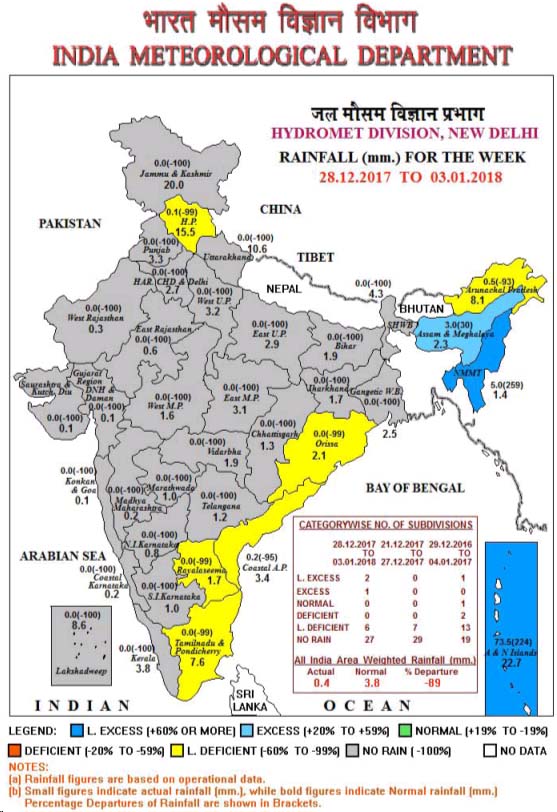
The subdivision-wise weekly rainfall distribution is presented in Fig.1. Rainfall was L. excess in 4, excess in 4, normal in 11, deficit in 2, L. deficit in 10 and no rain in 5 out of 36 meteorological sub-divisions.
Cumulative Seasonal rainfall (1st June to 30th September 2017)
-
The subdivision-wise seasonal rainfall distribution is presented in
Fig. 2. Rainfall was L. excess in 0, excess in 5, normal in 25, deficit in 6, L. deficit in 0 and no rain in 0 out of 36 meteorological sub-divisions.
State-wise distribution of number of districts with excess, normal, deficient, scanty and no rainfall during monsoon season rainfall (1st June to 30th September 2017)
-
In the country, 4% districts received large excess, 12% districts received excess and 50% districts normal rainfall during monsoon season so far. However, 33 districts received deficient, 1% districts received large deficient rainfall and 0% districts received no rainfall and 0 districts received no data. (Table-1).
Weekly rainfall departure (%) at different IMD subdivisions (2017)
-
During the week under report 4 Sub-divisions viz.; Assam & Meghalaya, Telangana, Rayalaseema and South Interior Karnataka received large excess rainfall, 4 Sub-divisions viz.; Arunachal Pradesh, Odisha, North Interior Karnataka and Coastal Karnataka received excess rainfall, 11 Sub-divisions viz.; Nagaland, Manipur, Mizoram & Tripura, Sub Himalayan West Bengal & Sikkim, Gangetic West Bengal, Jharkhand, Chhattisgarh, Konkan & Goa, Coastal Andhra Pradesh, Kerala, Tamil Nadu & Pondicherry, Lakshadweep and Andaman & Nicobar Island received normal rainfall and remaining 12 Sub-divisions received either deficit / large deficit / no rainfall.
(Table-2).
Table 1. State wise distribution of number of districts with excess, normal,
deficient, scanty and no rainfall (01.06.2017 to 30.09.2017)
S. NO. |
STATES |
LE |
E |
N |
D |
LD |
NR |
ND |
TOTAL |
1 |
A & N ISLAND(UT) |
0 |
0 |
1 |
2 |
0 |
0 |
0 |
3 |
2. |
ARUNACHAL PRADESH |
1 |
1 |
5 |
5 |
1 |
0 |
3 |
16 |
3. |
ASSAM |
0 |
3 |
17 |
6 |
0 |
0 |
1 |
27 |
4. |
MEGHALAYA |
1 |
0 |
1 |
2 |
0 |
0 |
3 |
7 |
5. |
NAGALAND |
1 |
0 |
1 |
1 |
1 |
0 |
7 |
11 |
6. |
MANIPUR |
1 |
0 |
1 |
2 |
0 |
0 |
5 |
9 |
7. |
MIZORAM |
1 |
1 |
1 |
0 |
0 |
0 |
6 |
9 |
8. |
TRIPURA |
0 |
2 |
2 |
0 |
0 |
0 |
0 |
4 |
9. |
SIKKIM |
0 |
1 |
3 |
0 |
0 |
0 |
0 |
4 |
10. |
WEST BENGAL |
0 |
1 |
15 |
3 |
0 |
0 |
0 |
19 |
11. |
ODISHA |
0 |
1 |
20 |
9 |
0 |
0 |
0 |
30 |
12. |
JHARKHAND |
0 |
3 |
13 |
8 |
0 |
0 |
0 |
24 |
13. |
BIHAR |
0 |
1 |
21 |
16 |
0 |
0 |
0 |
38 |
14. |
UTTAR PRADESH |
0 |
0 |
24 |
44 |
4 |
0 |
0 |
72 |
15. |
UTTARAKHAND |
0 |
3 |
8 |
2 |
0 |
0 |
0 |
13 |
16. |
HARYANA |
0 |
0 |
7 |
14 |
0 |
0 |
0 |
21 |
17. |
CHANDIGARH(UT) |
0 |
0 |
1 |
0 |
0 |
0 |
0 |
1 |
18. |
DELHI |
0 |
0 |
3 |
5 |
0 |
0 |
1 |
9 |
19. |
PUNJAB |
0 |
3 |
7 |
9 |
1 |
0 |
0 |
20 |
20. |
HIMACHAL PRADESH |
0 |
0 |
9 |
2 |
1 |
0 |
0 |
12 |
21. |
JAMMU & KASHMIR |
2 |
3 |
10 |
5 |
0 |
0 |
2 |
22 |
22. |
RAJASTHAN |
4 |
6 |
9 |
14 |
0 |
0 |
0 |
33 |
23. |
MADHYA PRADESH |
0 |
0 |
23 |
28 |
0 |
0 |
0 |
51 |
24. |
GUJARAT |
5 |
8 |
16 |
4 |
0 |
0 |
0 |
33 |
25. |
DNH & DAMAN(UTs) |
0 |
1 |
0 |
0 |
0 |
0 |
0 |
1 |
26. |
DIU(UT) |
1 |
0 |
1 |
0 |
0 |
0 |
0 |
2 |
27. |
GOA |
0 |
0 |
2 |
0 |
0 |
0 |
0 |
2 |
28. |
MAHARASHTRA |
0 |
8 |
17 |
11 |
0 |
0 |
0 |
36 |
29. |
CHHATISGARH |
0 |
3 |
16 |
8 |
0 |
0 |
0 |
27 |
30. |
ANDHRA PRADESH |
0 |
4 |
9 |
0 |
0 |
0 |
0 |
13 |
31. |
TELANGANA |
0 |
0 |
7 |
3 |
0 |
0 |
0 |
10 |
32. |
TAMILNADU |
5 |
15 |
12 |
0 |
0 |
0 |
0 |
32 |
33. |
PONDICHERRY(UT) |
0 |
1 |
1 |
0 |
0 |
0 |
2 |
4 |
34. |
KARNATAKA |
1 |
10 |
16 |
3 |
0 |
0 |
0 |
30 |
35. |
KERALA |
0 |
0 |
13 |
1 |
0 |
0 |
0 |
14 |
36. |
LAKSHADWEEP(UT) |
0 |
0 |
1 |
0 |
0 |
0 |
0 |
1 |
TOTAL |
23 |
79 |
313 |
207 |
8 |
0 |
30 |
660 |
CATEGORYWISE DISTRIBUTION OF DISTRICTS OUT OF THE 630 WHOSE DATA RECEIVED |
4% |
12% |
50% |
33% |
1% |
0% |
|
|
CATEGORY |
NO. OF STATE/UT |
L. EXCESS |
4 |
EXCESS |
12 |
NORMAL |
50 |
DEFICIENT |
33 |
L.DEFICIENT |
1 |
NO RAIN |
0 |
>
NO DATA |
|
Crop
weather conditions
(01st to 07th October 2017)
The crop weather conditions in different states as reported by the cooperating centers of AICRPAM are as under:
Maharashtra
Vidarbha region
T max 33.8 °C (normal 33.3 °C), T min 22.7 °C (normal 22.2 °C). RH I 90% (normal 85 %), RH II 52% (normal 51%). Evaporation rate 5.0 mm (normal 4.6 mm), Wind speed 1.7 km/hr (normal 4.8 km/hr) and BSH 8.5 hrs (normal 7.0 hrs). Maximum temperature across the week was 0.5°C below normal and the minimum temperature was 0.5°C above normal. In Vidarbha subdivision rainfall during June 1- September 29 amounted to 730.9.mm (-23%). Akola location recorded 455.3 mm rains(-31%) during 1 June-30 September. Timely sown (25/26 MW) early variety of soybean showing signs of physiological /harvest maturity. Pigeon pea crop in active vegetative stage shows good vigour. Infestation of sap sucking pests/boll worm prevails in cotton. Isolated incidence of pod borer also reported in soybean crop. In Vidarbha Amravati division recorded 94.5% kharif sowing (31.35 lakh ha) majorly with soybean 14.10 lakh ha, pigeonpea 4.327 lakh ha and cotton 9.835 lakh ha. Nagpur division recorded 91.3% kharif sowing (17.57 lakh ha) majorly with cotton 6.620 lakh ha, rice 6.447 lakh ha (87.8%), soybean 2.457 lakh ha and pigeonpea 1.796 lakh ha. Agricultural operations like Drying and threshing of blackgram underway. Harvesting of early soybean being carried out. Rainfed early rabi sowing preparations are underway in harvested mono-crop fields of greengram and blackgram. Weeding of tree basins of plantations being carried out. Plant protection measures are being undertaken in cotton (sap sucking pest/bollworm) and late soybean (leaf eating caterpillar) underway. Cotton through square initiation/flowering/boll formation phase. Earlier sown (25/26 MW) early varieties soybean towards physiological/harvest maturity stage. Sorghum at grain formation/development stage and pigeon pea through secondary branching phase. Sweet corn cobs are being harvested. Acid lime/papaya/Aonla at harvest stage as per maturity of fruits.
Konkan Region
Atmospheric condition was clear during morning hours around Dapoli during last week. Therefore 2.6 to 7.8 of Bright sunshine hours was recorded during last week. During last week 25.4 mm rainfall was recorded at Agrometeorological observatory, Dr. B.S.K.K.V. Dapoli. The maximum and minimum temperature ranged from 24.0 to 31.4 and 21.5 to 24.0 oC respectively. Wind velocity ranged from 1.1 to 3.9 km and wind was blowing from easterly Direction. Agricultural operations like harvest early rice varieties during clear sunny day are in progress. Medium & late duration rice varieties and fingermillet crops are in flowering to grain filling stage. No major pests and diseases were noticed.
Assam
Weather during the last week was partially cloudy. Daily average maximum temperature ranged from 32.1 degree centigrade to 34.4 degree centigrade. On the otherhand normal daily maximum temperature during the week ranged between 30.8 to 31.4 degree centigrade. Daily minimum temperature goes up to 26.6 degree centigrade which was 2.2 degree centigrade higher than normal. Morning relative Humidity ranged between 95-99 whereas afternoon RH ranged between 76-91%. Mean windspeed was 1.55 km/hr. whereas mean BSSH was 3.4 hrs during the week. Agricultural operations like Second split of urea at panicle initiation stage for medium duration varieties. Sowing of pulses such as greengram, blackgram etc. are continuing.. Sali rice is in maximum tillering/panicle initiation stage and greengram and blackgram are at seedling stage. No major pests and diseases were noticed.
Gujarat
No rainfall received in Gujarat state during this week. The actual average maximum temperature is 0.2°C and minimum temperature is 0.6°C higher as compared to their normal values. Agricultural operations like Weeding of late sown crops and Harvesting of early maturing crops. Reproductive and maturity stages of kharif crops.
Haryana
Maximum temperature was slightly higher during later period of the week whereas the minimum temperature was higher during initial period. The clear weather prevailed during the week. The cumulative pan evaporation 30.1 mm which was 8.1 mm lower over the normal, the sunshine hours varies from 2.0 to 8.4 hrs. Westerly dominated wind blow with variable wind speed and direction. Agricultural operations like Picking in cotton, harvesting and threshing of ripen Bajra crops, harvesting and threshing of non-basmati rice varieties are going on. Cotton in ball maturity, Bajra in physiological maturity respective to date of sowing, Rice in reproductive to maturity stage.
Uttar Pradesh
West Uttar Pradesh
Light to moderate cloud in the atmosphere and no rainfall forecast from 27 September to 01 October. Maximum and minimum temperature may be 1-20C above to its normal. South-westerly/ South-Easterly winds may be prevailing on 4 .0 to 7.0 km/hr which would be 2-3 kmph above to its normal during these days, therefore weather will be mainly dry in this week. Insects and pest may be appeared in standing crop and animals also. Paddy , Maze, Sorghum , Pearl millet, Sugarcane , Pulses and vegetables are are going on good condition. Agricultural operations like Paddy: Irrigation, top dressing Urea and spray pesticide. Maize: Harvest mature crop. Sorghum: Spray pesticide. Black Gram: Spray pesticide and harvest mature crop. Green Gram: Spray pesticide and harvest mature crop. Pigeon pea : Spray pesticide . Toria: Weeding. Brinjal / Chilies: . Transplanting, irrigation, weeding , plucking, marketing, spray pesticide . Leafy Vegetable : Sowing, cutting and marketing and irrigation . Animal: Protect from common diseases are in progress. Paddy : PI /Flowering/ Milking, Maize : Dough/ Maturity, Pigeon pea : Vegetative/ Branching , Black Gram: Padding/ Maturity, Green Gram: Padding/ Maturity, Toria: Emergence/ vegetative, Vegetables: Flowering and Fruiting.
East Uttar Pradesh
No rainfall occurred in East Uttar Pradesh region of Uttar Pradesh state during the week. Agricultural operations like Top dressing of N fertlizer in long duration varieties of paddy. Harvesting of short duration varieties of paddy and maize, Plucking of urd/mung. Thinning in toria, Sowing of early potato. Short duration varieties of paddy are in maturity stage while medium and long duration varieties of paddy are in PI to miling stage, Pigeon pea is in vegetative stage.
Himachal Pradesh
The maximum temperature during the week ranged between 20.5 to 27.5°C which was above normal by 0.9 to 1.9°C and minimum temperature ranged between 15.5 to 17.5°C which was below normal by 0.1 to 1.0°C during most part of the week. The relative humidity varied between 76-98% and sunshine between 0.0-9.0 hrs/day with variable sky conditions (octa 1-8). The evaporation rate varied between 0.0 to 3.7 mm/day. Agricultural operations like Farmers are arranging the fodder for cattle and dairy animals from rice and maize fields are in progress. MAIZE: Physiological maturity stage; RICE: Grain filling stage; vegetables: Picking stage.
Jammu & Kashmir
Mainly clear weather prevailed during this week with no rainfall. The maximum temperature remained above normal by 1-2 0C and minimum temperatures remained in normal limits. The morning and evening relative humidity was observed in the range of 76 to 91 % and 45 to 60 % , respectively. The total evaporation observed 43.4 mm and sunshine in the range of and 4.1 to 9.1 hrs during this period. Agricultural operations like Sowing of toria crop under conserved moisture in rainfed condition,e arly transplanted varieties of cole crops from nursery to field is in progress,irrigate the paddy, maize and pulse crops, irrigation in horticulture crops are in progress. Maize is at reproductive stage. Kharif pulses is at pod formation to physiological maturity stage. Early transplanted paddy is at grain formation stage. Normal transplanted paddy is at spike emergence/anthesis stage. Late transplanted paddy is at vegetative stage and basmati rice is at flag leaf /spike emergence stage. Moderate intensity of stem borer in maize and brown spot in paddy crop was noticed.
Rajasthan
Dry weather recorded in the entire state and at the centre during this week. Agricultural operations like Harvesting of pulses, early sown maize and groundnut. Cleaning of fields and field preparation for rabi sowing, sowing of gram and mustard, are in progress. Late sown maize - milking soybean- grain development stage to physiological stage.
Tamil Nadu
Maximum temperature: 36.9°C (normal 36.3°C), minimum temperature: 25.6°C (normal 22.5°C), RH: 72.6% (normal 77 %), rainfall: 0.0 mm (normal 27.5 mm). Maximum temperature across the week was 0.6°C above normal and the minimum temperature was 3.1°C above normal. General Weather situation in Tamil Nadu: Ø Maximum temperature range of 30°C - 38°C prevailed over the state except Kodaikanal and Uthagamandalam (17°C - 19°C) during the period under report. Ø Minimum temperature range of 21°C - 29°C prevailed over the state while Kodaikanal and Uthagamandalam recorded minimum temperature range of 11°C - 13°C during the same period. Ø With respect to daily rainfall, rainfall occurred at isolated places on 24.9.2017, at many places over the state on 25.9.2017, at a few places over Tamil Nadu from 26.9.2017 to 28.9.2017 and during the week. Ø With regard to weekly rainfall, large excess rainfall was received in Ariyalur, Cuddalore, Dharmapuri, Namakkal, Perambalur, Salem and Thanjavur districts whereas Erode, Karur, Krishnagiri, Madurai, Nagapattinam, Pudukkottai, Tiruvarur, Tiruchirapalli and Villupuram districts recorded excess rainfall. Normal rainfall was obtained in Chennai and Virudhunagar districts. All other districts received deficit rainfall during week ending 28.9.2017. Agricultural operations like field preparation for northeast monsoon season is in progress. Cotton, sorghum, pulses and maize are in vegetative stage. Sugarcane is in grand growth stage to maturity stage. Onion is in nursery stage. Banana is in bunch development stage.
|
|